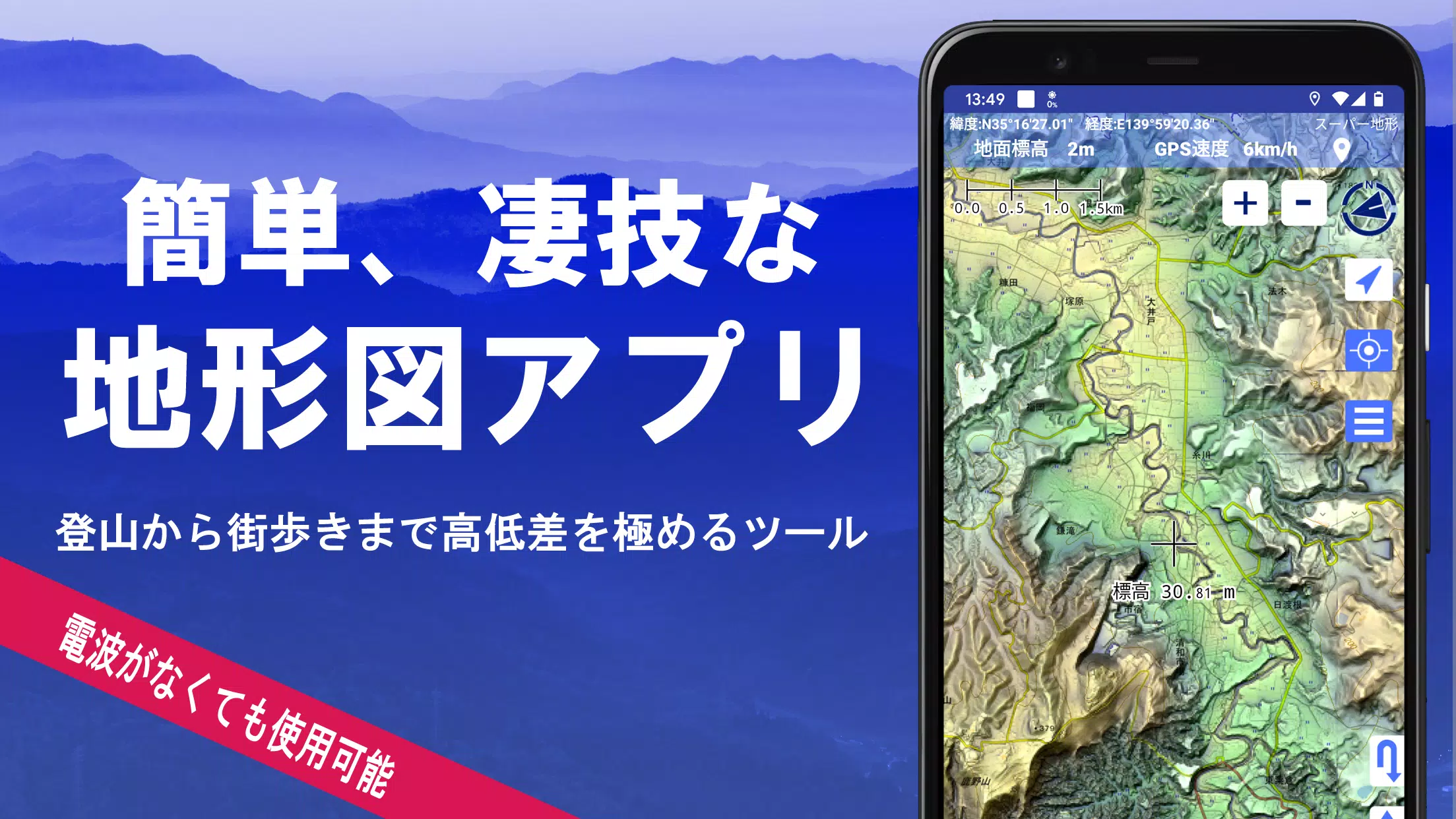
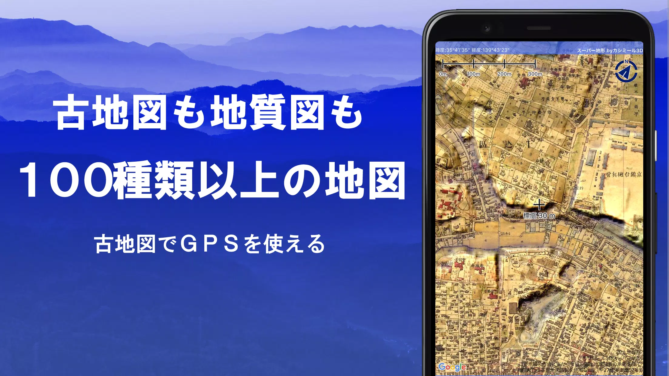
Discover the power of over 100 types of maps, including those from the Geographical Survey Institute, designed to enhance your experiences from mountain climbing to exploring urban areas. Whether you're navigating the steep inclines of a mountain or strolling through the city, these maps provide a detailed view of the terrain, helping you make the most of every journey.
Our application was honored with the 2018 Japan Cartographic Society Award for Best Work, a testament to its comprehensive features and utility. Leverage our unique "super terrain data" technology to emphasize and better understand the terrain you're exploring. You'll also have access to a wide range of maps, from the Geospatial Information Authority of Japan's offerings to topographic, geological, historical, and prewar Ordnance Survey Department maps.
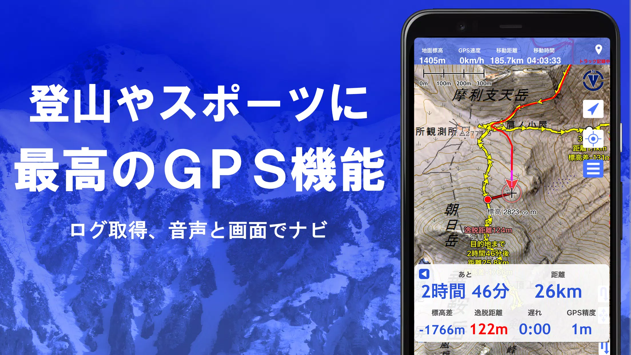
Record your adventures with ease using the GPS function, which supports GPX log input/output and editing. Whether you're hiking, climbing, or simply walking around town, our app is equipped with features to enhance your outdoor experience, including GPS navigation with audio support and data recording/editing capabilities.
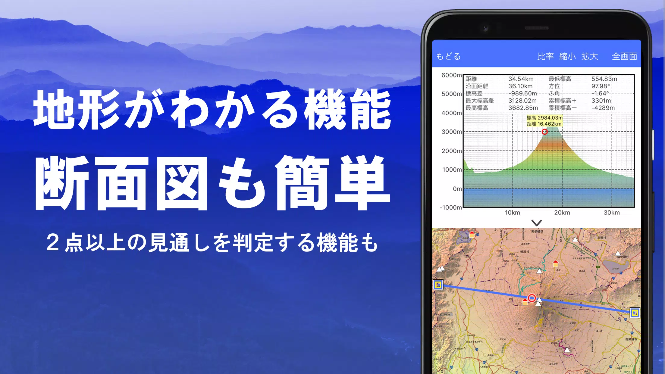
Utilize the visibility determination function for creating cross-sectional diagrams, observing landscapes, and even assessing radio communication possibilities. The app can also display buildings, adding another layer of realism to your map usage. Our 360° panoramic view function helps you identify mountains by name, and you can track the positions of the sun, moon, and your GPS points.
For those venturing into areas without a signal, our GPS function, bulk map download, and map cache features ensure you remain connected and informed. You can associate photos with specific points, display contour lines generated from elevation data, and view MGRS (UTM) grids. Additionally, our app supports the reading, displaying, and editing of GIS data from GeoJSON files, allowing you to draw shapes and utilize the app overseas.
Map printing and PDF output are available, and for those who prefer a darker interface, we support a dark theme. Whether you're navigating or simply exploring, our app provides a rich, user-friendly experience tailored to your needs.
Our app offers an extensive selection of maps, with more than 100 types available, including combinations of our super topographic data and maps from the Geospatial Information Authority of Japan. Please note that while aerial photographs are categorized by age group, coverage may vary, with "Latest" and "around 1974" providing broader coverage. Enjoy a free 5-day trial of our super terrain data maps after installing the app.
Effortlessly draw cross sections through any point on the map, and utilize the visibility judgment function to account for the Earth's curvature and atmospheric differences. This feature is invaluable for planning climbing routes, assessing wireless visibility, and understanding the terrain. Where PLATEAU building data is available, you can include buildings in your cross-sectional views.
Customize your map experience with the elevation palette function, which allows you to change the map background color to your preferred gradation in 1cm increments.
Explore panoramic observation maps to identify mountains from any point on the map. Our 360° panoramic view, which can be linked to your smartphone's compass, is perfect for mountain identification. View the sun and moon, including moon phases, to plan for phenomena like Diamond Fuji and Pearl Fuji. You can also see GPS point locations and create panoramic views of overseas mountains.
Harness the power of your smartphone's GPS to record your location and track your journeys. Our high-precision position measurement is designed for serious outdoor use, displaying recorded tracks with parameters such as elevation, speed, time, and elapsed time. The point alarm function alerts you with voice and alarm sounds as you approach designated points. You can also display photos associated with specific locations and send the map center position to NaviCon.
Replay your entire track at once with our GPS track summary playback feature. It automatically matches and displays photos taken during your journey, with icons at the photo locations that you can tap to view.
Navigate along preset tracks with our Track Navi feature, which uses your smartphone's GPS. If you stray from the path, you'll be alerted by voice or alarm, ensuring you stay on course. Additionally, our route and point navigation functions are perfect for urban exploration and targeted navigation.
Manage your GPS-related point, route, and track data easily with our folder-based system, displayed in a clear tree format. You can create tracks directly on the map and import/export them in GPX format from various sources.
Continue your exploration even in areas without a signal, thanks to our bulk download and map cache functions. These ensure you have all the necessary maps for your adventure, preventing any surprises upon arrival.
Our app remembers your previous map views, allowing you to quickly return to locations you've explored before.
Import and use custom maps created with Kashmir 3D's map cutter. Display and utilize your own maps and scanned images, ensuring each image is approximately 256 x 256 pixels. Send the resulting kmz file to Super Terrain via email or Cloud Drive.
Display, edit, and create new shapes using points, linestrings, and polygons from GeoJSON format files.
Print any area of the map at a specified scale or generate a PDF for easy sharing and reference.
Exchange GPS data in GPX, KML, and GDB formats with other apps, including Kashmir 3D on your PC, and utilize trajectory data from mountain climbing sites.
Back up all your app data (excluding map caches) and restore it even if you delete the app or encounter a smartphone malfunction. An automatic backup feature using Google Drive ensures your data remains up-to-date.
Some features, such as maps using super terrain data, GPS track functions, and cross-sectional views, require in-app purchases. After purchasing, the number of place name search results increases. The annual fee is 780 yen/year, and a 5-day free trial is available upon first installation. To purchase, navigate to [Settings] - [Purchase to remove functional restrictions] within the app. You can manage automatic updates and cancellations through Google Play.
Please note that prices may be revised with future feature enhancements, making early purchases advantageous.
The copyright holder and developer are not responsible for the outcomes of using this application. When starting GPS for the first time, allow the use of location information services. Continuous GPS use may drain your battery, so if your device is also used for emergency communication, carry a spare battery. For a detailed explanation of the navigation function, refer to the PDF at https://www.kashmir3d.com/online/superdemapp/superdem_navi.pdf.
Be aware that some smartphones may interrupt or fail to record tracks due to power-saving features. While turning off the screen can prolong recording, it's not a permanent solution.
"Clair Obscur: Expedition 33 Hits 1 Million Sales in 3 Days"
Top 10 Liam Neeson Films Ranked
Roblox Deep Descent: January 2025 Codes Revealed
Ragnarok V: Returns Beginner's Guide - Classes, Controls, Quests, Gameplay Explained
How to Feed Villagers in Necesse
Bitlife: How to Complete the Renaissance Challenge
Bahiti Hero Guide: Mastering the Epic Marksman in Whiteout Survival
Expedition 33 Patch Fixes Soft-Lock Bug

Persona 5 Phantom X Hits Mobile
May 01,2026

MMORPG Albion Online Drops Its Most-Anticipated Update Abyssal Depths
Apr 29,2026

Sonos Sale Slashes Prices on Arc Soundbar, Era 300
Apr 29,2026
Wargroove 2 Pocket Edition Sets Mobile Launch
Apr 24,2026

MathOn Challenge Launches on iOS and Android
Apr 24,2026
 Category
 Download


Discover the best beauty apps to enhance your makeup and skincare routine! This curated collection features top-rated apps like Magic Beauty Makeup Camera, Beauty Plus Princess Camera, Makeup Ideas, FOREO (for skincare devices), Easy hairstyles step by step, FaceTone, SnapArt, Makeup Photo Editor, Beauty Make Up Photo Editor, and Makeup Camera: Selfie Editor & Beauty Makeup. Transform your selfies, find makeup inspiration, and explore innovative skincare tools – all in one place. Find the perfect app to achieve your desired look and elevate your beauty game today!
FaceTone
Makeup Camera: Selfie Editor & Beauty Makeup
Beauty Plus Princess Camera
SnapArt Pro Ai Photo Editor
Makeup Ideas
FOREO For You
Makeup Photo Editor